
Major leap for mangrove conservation as upgraded Global Mangrove Watch delivers unmatched accuracy to mangrove data at global and local scales
On World Mangrove Day, the Global Mangrove Watch platform (GMW) will release its updated mangrove extent and change maps, now available through 2025, which reveals a small gain in mangrove cover globally, but continued losses in some regions. The maps are more detailed than ever before, making the world’s leading mangrove monitoring platform a powerful tool not just for scientists and governments, but also for local communities, park managers, and project planners to protect better and manage mangroves.
The determination to safeguard the remaining 147,283 square kilometers of mangroves is growing at all levels from international to local. Mangroves are unique coastal ecosystems that harbor incredible biodiversity and provide food, shelter, and livelihoods. They stabilize coastlines, protect coastal communities from storms, and sequester carbon at rates up to four times higher than terrestrial forests per hectare.
Continued losses in other areas
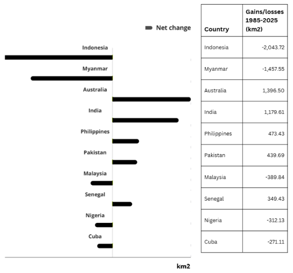
However, the Global Mangrove Watch data also show that gains in mangrove cover are unevenly distributed, with notable increases in India, the Middle East and China, as well as in areas with lower levels of direct human pressure that facilitate natural regeneration. In contrast, other regions show net losses in the past 4 decades, including Myanmar, Indonesia, Malaysia and Nigeria, driven by a mix of anthropogenic and climatic factors. Since 2015 however, the extent of mangroves has become more stable in some countries, like in Indonesia.
Increases in mangrove cover are partly the result of afforestation and restoration efforts. The ecological success of these restored forests depends strongly on the techniques used, since the majority of planting initiatives do not successfully establish functional mangrove forests. Instead, community-based ecological restoration is considered best practice and is gaining increasing recognition and uptake.
New GMW maps deliver 6x higher resolution, boosting local action
GMW has significantly improved the accuracy of its mangrove extent maps. The new baseline maps, now available until 2025, produced at 10-meter resolution, offer six times the spatial detail of previous versions,making it easier to identify even small features in mangrove areas. Maps tracking mangrove loss and recovery are now available at 30-meter resolution and extend coverage from 1985 to 2025, a substantial expansion from the previous 1996-2020 timeframe.
New data shows previously unmapped mangrove areas and territories
The latest update has also uncovered previously unmapped mangrove areas. Mangroves are now identified in 128 countries and territories, six more than before. While these new areas are often small and scattered, they are important for conservation, especially as they connect to adjacent ecosystems, such as coral reefs.
Most complete and up-to-date mangrove monitoring platform
The GMW platform is free to use and is continually updated with new datasets. With high-resolution maps and information on a large range of parameters, including coastal protection and carbon, the GMW serves as the first point of entry to understand the state and values of mangroves across our planet.
Explore the platform now and join the webinar on [date] to learn more.
Top 10 gains and losses by country